
It plans the route the way the regulations would
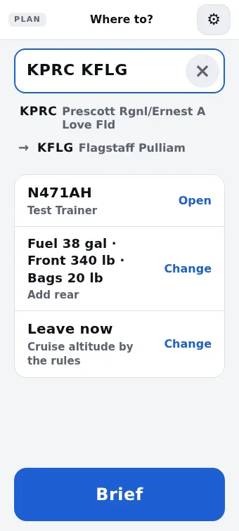
Type where you're going. Ahead picks a VFR cruising altitude for your direction of flight, and checks that every leg stays at least 1,000 feet above the highest terrain within 2 nautical miles of the line, apart from the climb out and the pattern.
It goes under or around Class B rather than asking you to get a clearance, as long as a legal way exists. It steers clear of Class C and D, restricted areas, MOAs and alert areas when the detour is reasonable. If there's no oxygen on board it keeps the plan at or below 12,500 feet, and it plans the fuel reserve 91.151 asks for, day or night.
You don't choose things the rules already decide. The altitude, the runway that fits the wind and the altimeter setting are worked out for you, and you can still change them.
Fuel stops where you can buy your fuel
Tell Ahead which fuels your engine takes and how much the tanks hold. On a long trip it picks the stops for you: airports that sell your grade, with the hours someone is there to fuel you, spaced so every leg lands with the reserve. Each leg shows the fuel you should land with.
Don't like a stop? Swap it for one of the next three, each with what it costs you, or remove it and let the plan find another way. In the air, the stop's top of descent says so, along with the fuel you should have when you land.
One brief that ends in GO or NO-GO
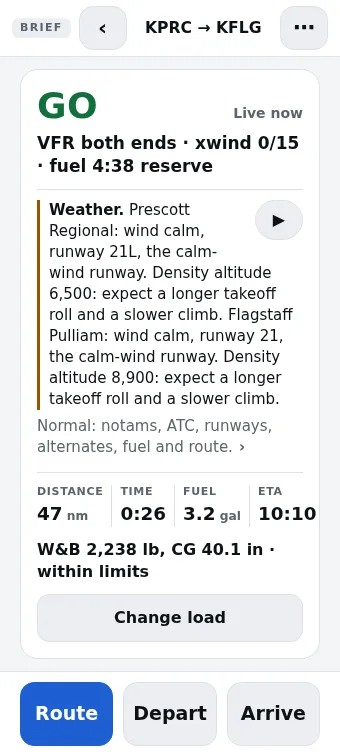
The brief follows 91.103 in the order you learned it: weather along the route and at each field, TFRs and the NOTAMs that touch your flight, winds, the runways you'll use with the takeoff and landing distances from your own POH, weight and balance, fuel and alternates.
The GO or NO-GO comes from fixed rules in the app, the same way every time. Anything that could stop the flight is at the top, with a button that fixes it when there's something to fix. If you want it read to you, Ahead talks through the brief the way an instructor would, rather than reading the screen back.
In the air it talks you through the flight
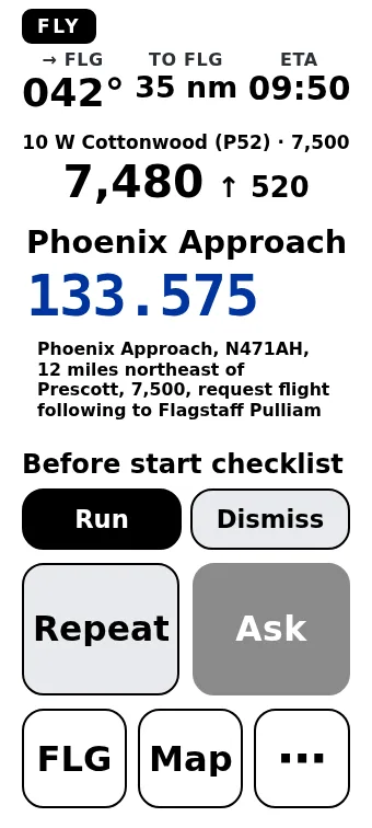
Fly mode shows one thing at a time: the next call, its frequency and the words to say, in text big enough to read with the airplane moving. A voice tells you when to switch frequencies, when to start down, and when you're getting close to airspace, terrain or traffic. At night the whole screen turns red to protect your night vision.
The Fly map follows your track and shows only what matters in the next few minutes at your altitude: the airspace you could bump into, the terrain near your altitude, traffic converging on you, and your fuel stops with the time you'll get there. Ask it a question out loud and it answers from your plan and your POH.
Your airplane's numbers, read from your POH
Ahead isn't built around one airplane. Give it your POH as a PDF and it reads the speeds, fuel burn, takeoff and landing tables, weight and balance limits and checklists on your phone. You check what it found before anything uses it, and anything it isn't sure of is flagged for you to fill in.
The checklists come up at the right moments, before taxi, at the run-up and before landing. They're offered on screen for you to run or dismiss, and they're never read aloud over the radio traffic.
It keeps working with no signal
Plan and brief on the ground while you have a connection. After that, everything Ahead does in flight runs on the phone: the maps, the terrain, the callouts and the answers to your questions. It works the same in airplane mode, and we test that it does. The FAA data, maps and terrain download by themselves over Wi-Fi.
What's coming next
Radio is coming next. Pair a Bluetooth aviation radio and Ahead will listen to the ATIS for you, and show a live transcript of ATC with your squawk and the frequency you've been given picked out.
We haven't tested it on a real radio yet, so it isn't in the beta.
Join the Android beta
We're adding pilots a few at a time. Leave your email and we'll send you an invite when there's a place. We'll only use it for the beta. How we handle your email.
Questions pilots ask
Which airplanes does Ahead work with?
Any single-pilot airplane you fly VFR. You give Ahead your POH as a PDF and it reads the numbers it needs on the phone: speeds, fuel burn, takeoff and landing distances, weight and balance limits and the checklists. You check what it read before it uses it.
Does it work without a cell signal?
Yes. Plan and brief on the ground with a connection, and everything after that, including the maps, terrain, callouts and questions you ask out loud, runs on the phone in airplane mode. The FAA data downloads by itself on Wi-Fi.
Is Ahead an approved source for a preflight briefing?
No. Ahead is a planning and situational-awareness aid. It doesn't replace an official briefing, current charts or the pilot in command's judgement.
Is there an iPhone version?
Not yet. Ahead is Android only for now, and the beta is open to Android phones.
What does it do with the radio?
Today it shows you the call to make and the frequency to make it on. Listening to ATIS through a Bluetooth radio, and a live transcript of ATC with the squawk and frequency picked out, are coming. They haven't been tested on a real radio yet, so they aren't in the beta.